Posts

Man versus elephant in Jharkhand State of India.

Image
Villagers are forced to live on top of the tree. by Dr. Nitish Priyadarshi Elephant entering in a village. Herd of elephants destroying the huts. Village destroyed. People forced to live on top of tree . Villagers on tree. Other aspect of elephant. Roaming on the street of Ranchi city with its owner.

There was a time when Sea Monsters did exist.

Image
In many cultures of the world there are different stories of these ancient giant reptiles and their interactions with human beings. by Dr. Nitish Priyadarshi Fig. Kaliya Nag (cobra snake) There is nothing quite so frightening as the idea of a sea monster. Unlike T. Rex and other giant dinosaurs, which went extinct, might sea monsters live on? Might they lurk beneath the leaden cloak of the oceans, breaching occasionally into view? Through the ages, serious mariners have returned to port with accounts of huge, snaky beasts baring teeth and trailing feathery manes, undulating through the waves or rearing like a horse. Stories about water serpents have slithered into many cultures. But what about the science of sea monsters? In fact, there was a time when they did exist. About 250 million years ago Earth’s continents were gathered into one landmass, Pangaea. Shallow seas and the lack of significant marine predators created new niches for many reptiles that had developed on land. They wri...

Earthquake stopped life in Haiti. More stable areas are under threat.

Image
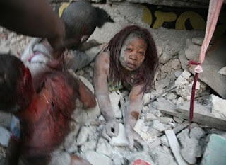
It seems Haiti is now history. by Dr. Nitish Priyadarshi All photo credits: www.huffingtonpost.com The 2010 Haiti earthquake was a catastrophic magnitude 7.0 Mw earthquake centred approximately 25 kilometres (16 mi) from Port-au-Prince , the capital of Haiti , which struck at 16:53:09 local time (21:53:09 UTC) on Tuesday, 12 January 2010. The earthquake occurred at a depth of 13 kilometres (8.1 mi). The United States Geological Survey recorded a series of aftershocks , fourteen of them between magnitudes 5.0 and 5.9. The International Red Cross estimates that there have been as many as three million people affected by the quake, and an estimated 45,000–50,000 deaths. Most of Port-au-Prince's major landmarks were significantly damaged or destroyed in the earthquake, including the Presidential Palace (though the President survived), the National Assembly building, the Port-au-Prince Cathedral , and the main jail. All hospitals were destroyed or so badly damaged that they hav...

Haiti Earthquake disaster.

Image
GeoEye-1 satellite from 423 miles in space. by Dr. Nitish Priyadarshi Above is a photo that contains an "AFTER THE QUAKE" satellite image of Port-au-Prince taken by GeoEye-1 satellite from 423 miles in space at 10:27 am EST on Jan. 13, 2010 as it moved from north to south over the Caribbean at a speed of 4 miles per second. Ground resolution is half meter (19 inches). This photograph was send to me by Mr.James Davis Manager of Digital Communications. You can see the Haitian National Palace located just to the right of the center of the image. It looks like a white inverted letter "E."To see the imagery at its best resolution you can zoom-in to any area within the image.The imagery clearly shows extensive damage throughout the city. One can see roads covered with debris from collapsed structures, people crowded in the streets and in open public places such as sports fields and stadiums. Many buildings appear to be flattened. The white-colored National Palace sho...

Importance of Medical Geology in present environment.

Image
It is now a globally emerging discipline. by Dr. Nitish Priyadarshi Humans live in lands. Most of them live in intimate contact with the immediate geological environment, obtaining their food and water directly from it. The unique geochemistry of these tropical environments have a marked influence on their health, giving rise to diseases that affect millions of people. The origin of these diseases is geologic as exemplified by dental and skeletal fluorosis, iodine deficiency disorders, trace element imbalances to name a few. Medical Geology is an emerging scientific discipline that examines the impacts that geologic materials and processes have on human and ecosystem health. Medical Geology: · Identifies and characterizes natural and anthropogenic sources of harmful materials in the environment. · Predicts the movement and alteration of chemical, infectious, and other disease-causing agents over time and space. · Provides an understanding of how people are exp...

Arsenic alarm in Bihar and Jharkhand Villages of India.

Image
Bihar and Jharkhand is facing one of the gravest natural disasters in the form of arsenic contamination of ground water. by Dr. Nitish Priyadarshi Thousands of people living in over hundreds of villages in different district of Bihar and Sahebganj district of Jharkhand state in India are facing serious threat to their health due to alarmingly high quantity of arsenic present in the underground water. Bihar is facing one of the gravest natural disasters in the form of arsenic contamination of ground water. In the first detailed study of ground water quality, the Department of Environment and Water Management, A.N.College, Patna, has already submitted Interim Reports to PHED and UNICEF about the alarming findings on arsenic poisoning cases in the districts of Patna, Bhojpur, Vaishali and Bhagalpur. The study was conducted from April 2004 to May 2006, the study area being confined to 10 kms. wide belt along the Ganga river as per the instructions of PHED and UNICEF. According to Dr.Ashok ...

Mayon Volcano in the Phillipines may errupt.

Image
Tens of thousands of people living within the danger zone of Mayon Volcano in the Philippines were forced to evacuate to emergency shelters in mid-December 2009 as small earthquakes, incandescent lava at the summit and minor ash falls suggested a major eruption was on the way. On the evening of Dec. 14, the local volcano observatory raised the alert level to Level 3, which means "magma is close to the crater and hazardous explosive eruption is imminent."This natural-color image of Mayon was captured on Dec. 15, 2009, by the Advanced Land Imager on NASA's Earth Observing-1 (EO-1) satellite. A small plume of ash and steam is blowing west from the summit. Dark-colored lava or debris flows from previous eruptions streak the flanks of the mountain. A ravine on the southeast slope is occupied by a particularly prominent lava or debris flow.The Phillipine Star said on Dec. 22 that "ashfall blanketed at least three towns in Albay, raising new health fears for thousands alre...